6. Post LAEP
This section covers the steps to take once your LAEP is complete, including considerations of refreshing the LAEP, using the LAEP to inform project planning and prioritisation and understanding the benefits the LAEP has supported.
Contents of this page
Check list: Sharing your LAEPs and making the most of the free services from the DSO Local Net Zero Team
Once your LAEP programme is complete, we recommend three key steps:
1. Share your LAEP data
- Send your LAEP and accompanying forecast data to the DSO Local Net Zero team. This helps us enhance our forecasts through the LAEP Support Framework, shaping network investment planning with your local needs in mind
2. Upload to LAEP+ and visualise your data
- Access and use LAEP+ to visualise your LAEP data and use LAEP+ functionality to shape and build projects and portfolios
3. Share outputs with stakeholders and collaborate on delivery
- Distribute your LAEP outputs to other collaborators to help move your plans forward into delivery. Enable stakeholder collaboration through the available LAEP+ stakeholder consultation function
Refreshing your data
We run our LAEP support framework and update our network planning forecasts annually through the DFES, and look to use any LAEP data shared with us in previous years once again.
As part of this, we re-engage with local authorities who have shared their LAEPs with us to understand if the LAEP still reflects the decarbonisation pathway for their local area.
Our planning process is repeated each year
Options available to update your plans and share these with us include:
- Sharing the original LAEP through a Data Dictionary
- Using one of our DFES scenarios, which you can select using our DFES Self Selector
- Using top level forecast numbers (e.g. the expected number of EVs in a local authority area) which can be shared using our DFES widget
We can use information shared through any of these ways to enhance our forecasts through our LAEP Support Framework.
Using LAEP data to plan and prioritise projects
One of the key benefits of a LAEP is that it can be a platform to be inform future project planning through the identification of priority areas for various low-carbon technology installations.
Our digital tools ChargePoint Navigator and LAEP+ can both support this use case, either by yourselves as a LAEP Practitioner, or by the local authority themselves.
This is done by initially using the data uploader functionality to upload geographical LAEP data outputs onto the tools. For example, priority areas for heat pump installation in LAEP+, or priority areas for charge point installations in ChargePoint navigator.
Planning projects and building portfolios in LAEP+
Use the Projects functionality to design your project. This functionality allows you to:
- Place technologies on the map, taking into account the data you have uploaded, and linking the technologies to existing buildings
- Create a building portfolio to apply technologies to a user selected subset of buildings, which could be based on specific locations and attributes
- Use our dynamically updated network data to get the latest view of available capacity at the local level
- Upload cost and carbon templates (or use our default settings) to get an indication of the project cost and expected carbon savings
- Get a budget price range if the project involves new connections, showing you the range of connections costs for historical projects of a similar size
- Share your project with us
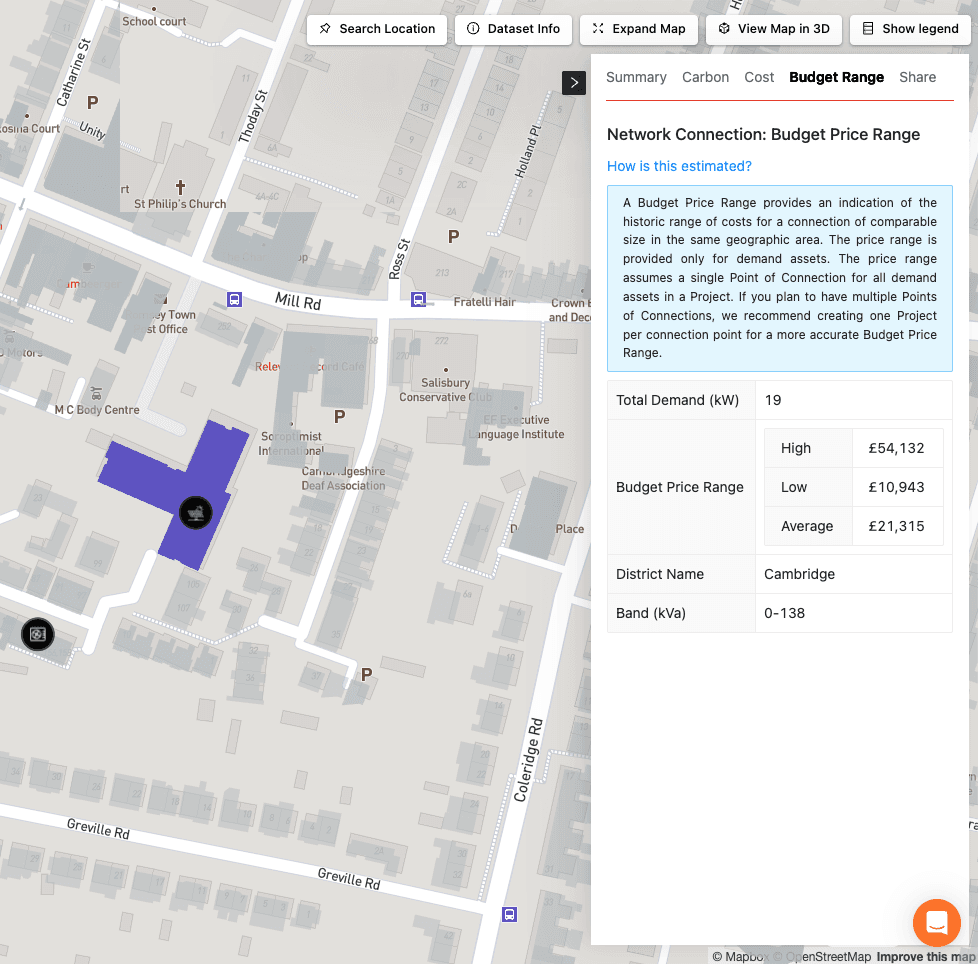
Budget price range example
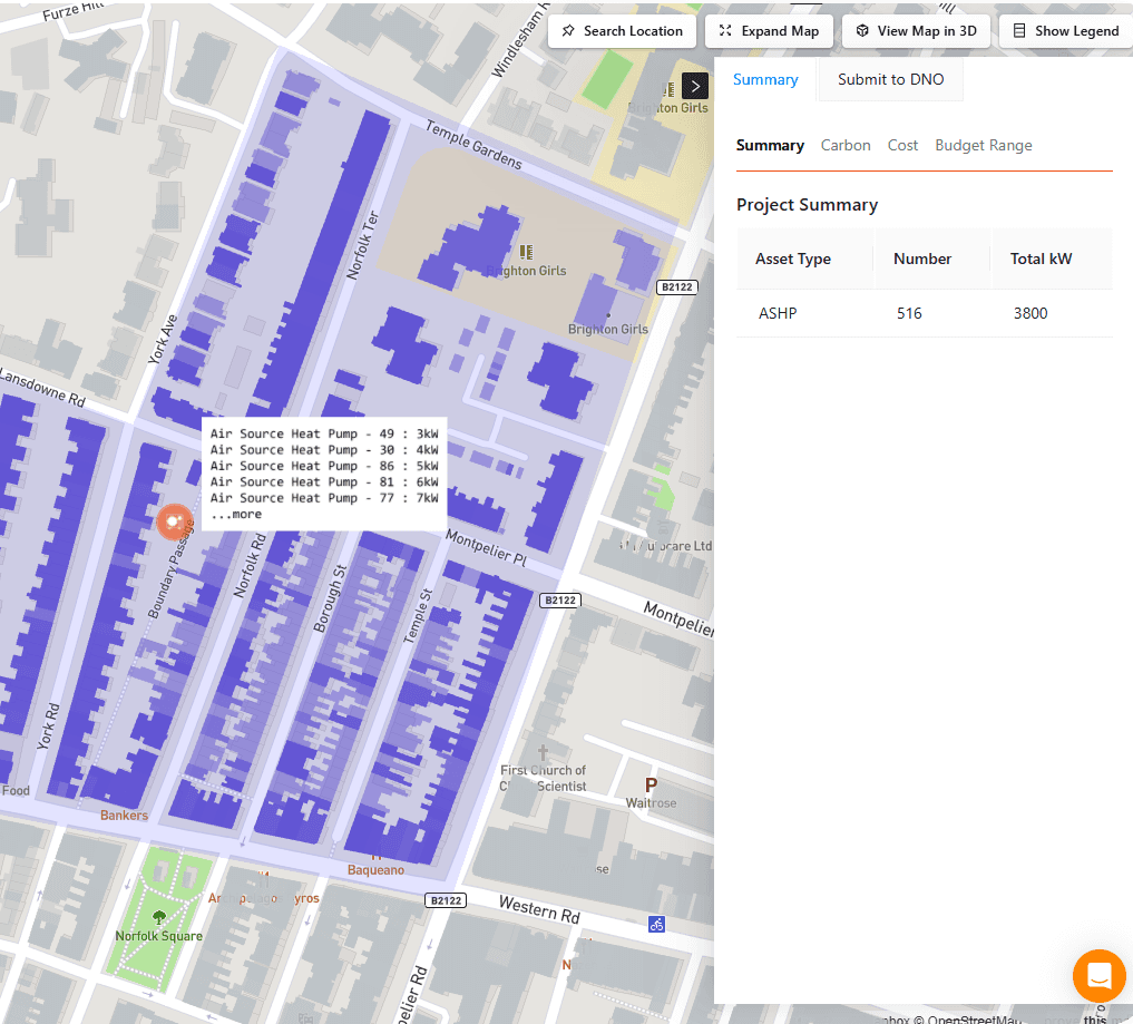
Example of a project summary in LAEP+
Planning charge point deployment in ChargePoint Navigator
In ChargePoint Navigator, once your LAEP data has been uploaded, you can use it to inform your charge point deployment. This could involve:
-
Using the datasets in ChargePoint Navigator such as pavement width, and households without access to offstreet parking to refine charge point locations
-
Use the connectable cables data to see exactly where might be best to install your charge points
-
Use the deployment monitoring functionality to monitor the progress of your installations over time
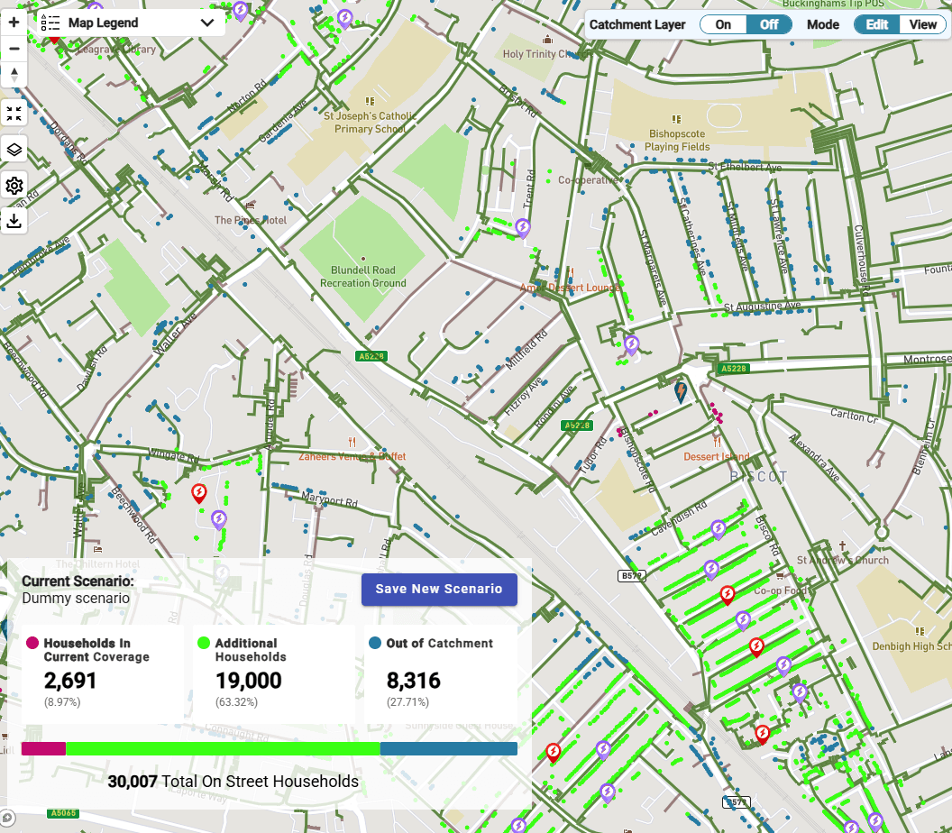
Using the data to plan your charge point locations
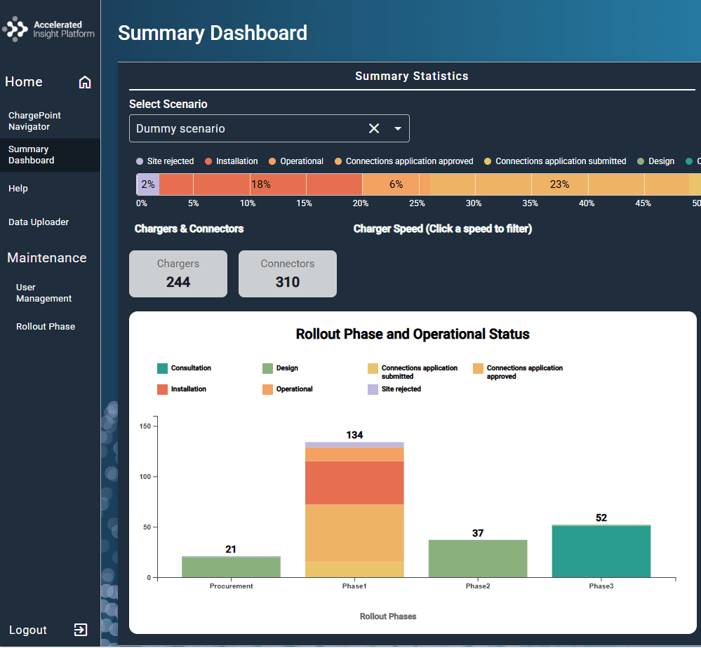
Using the summary dashboard to monitor your deployment
Using these digital tools means that you will have access to regularly updated data on our network, work on a collaborative platform with your stakeholders, and easily share information with us.
The value of developing a LAEP
There is a lot of value in developing a LAEP, mainly relating to two specific areas:
- Using the LAEP as an evidence base for planning future projects - ensuring projects are being delivered in the areas they will have the most impact
- Using the LAEP to update our network development plans - ensuring that your long term needs are catered for in our decision making
Shaping our local electric network plans with your local needs
As outlined in the previous page, in 2024, through our LAEP support framework we were able to include LAEPs covering 32 local authorities into our planning process.
As a result, we accelerated 70 substations investments.
Additional benefits
Additionally, the LAEP can be used to convene stakeholders to develop a coordinated strategy covering residential, commercial, and industrial stakeholder groups. This can mean that the entire areas energy needs are accounted for.
The benefits of LAEPs are also mentioned in detail in several reports, including:
- Beyond Targets: UK100's flagship report on the wider benefits of local climate action
- Local Area Energy Planning - The time and place is now: Energy Systems Catapult
Measuring benefits
To measure the value of your LAEP two things you could do are:
- Track the number of projects carried forward that have been informed by any LAEP outputs – Can be supported by our digital tools
- Request a playback from us on the impact your LAEP has had on our network development plans – This will not be immediately available due to our network planning process, but we can let you know when and what we will be able to share.
Applying for Connections
Guidance on connections applications can be found in the Delivery Phase section.